The History of Bucktown
By far, the most frequent question asked is the origin of the name “Bucktown.”
Though not documented, it is believed the term was coined early in the area’s history, probably the 1830’s, since many of the Polish settlers raised goats (the male is called a buck). The term faded away and emerged again in the 1920’s. Lending credence to this version, a long-time resident of the area recalls, “when my mother was little, there were only open fields where people raised goats. That’s how it became known as Bucktown. The Polish people called the area “kozie prery”, or “goat prairie.” Another version, again not documented and less credible, is that young toughs, members of a turn-of-the-century Polish gang, were called “bucks.”

Where exactly is Bucktown?
Those familiar with local history will argue that the boundaries correspond to the original boundaries of Holstein. Time does have a way, however, of distorting usage, and others will contend that Bucktown encompasses a much larger area. For the sake of harmony then, let us say that the Bucktown area is bounded roughly by Fullerton on the north, on the east by the Chicago River, North Ave. to the south, and on the west by Western Ave.
Our history predates the 1833 incorporation of Chicago as a town.
One of the earliest settlements outside of Fort Dearborn was located here. Many Poles fled their war torn homeland in 1831 and migrated to America, some to Chicago. Settling in and around Jefferson Township, some chose an area bounded by Fullerton, Damen, Armitage and Western, which later came to be known as Holstein. One can only imagine the small houses built near the groves of trees that punctuated the undulating terrain. Game was probably plentiful in the marshlands that dominated the low areas, which became increasingly frequent as one neared the north branch of the (now) Chicago River. Ideally situated near the river, the settlement was just a few miles away from Fort Dearborn. To the west, a now well traveled former Indian trail, now Milwaukee Avenue, helped to mitigate any feelings of isolation.

By the 1840’s the area had its own post office and hotel, the Powell House, at Milwaukee and Armitage. That Milwaukee Avenue, then the Northwestern Plank Road, ran in front of the Powell House was no accident. Mr. Powell, after erecting a flagpole in front of the hotel, announced to the road-building crew that if they aimed in the direction of the pole (they did) he would provide whiskey for a party (he did).
In early winter 1848, several hundred German immigrants, including tradesmen from Schleswig-Holstein, disembarked in Chicago. The newcomers, malnourished from the long voyage, had no provisions to carry them through the harsh winter. Marcus Nobles, who worked with Archibald Clybourn, founder of the first (1831) meatpacking house near Elston and Armitage, gave the new immigrants an ample supply of flour to settle here, and in 1854 established the town of Holstein. The area was annexed to the City of Chicago on February 13, 1863.
From the 1870’s to the beginning of World War I, there was a major influx of immigrants, largely Polish. Jewish immigration began in 1912 and Russian Jews settled here in the 1930’s. At one point there was a synagogue at 2330 West Armitage. Latin immigration in the 1960’s brought a new culture to the already cosmopolitan area. Another group of newcomers began to trickle in during the mid 1970’s, only this time the people could not be put into any ethnic category. Mostly middle class and native born, they recognized the amenities of Bucktown – affordable housing, both rental and ownership, good transportation, and proximity to the Loop and lakefront activities.
History of Bucktown Churches
To understand the history of Bucktown’s churches, we have to start with the founding of the first Polish Catholic parish in 1867, St. Stanislaus Kostka, at Noble and Bradley streets. During the next twenty years, the little colony around St. Stanislaus Kostka, also known as Kostkaville, expanded and other colonies were settled nearby. By 1910 the population of the area between the river and Milwaukee Avenue from Chicago Avenue to Fullerton was almost two-thirds Polish. English-speaking Chicagoans came to refer to the area as Little Poland or Polish Downtown, and Milwaukee Avenue became known as Chicago’s “Polish Corridor”. St. Stanislaus Kostka fathered numerous parishes, twenty-five in all, including St. Hedwig’s (1888) and St. Mary of the Angels (1897) some of Chicago’s finest ‘Polish Cathedrals”.
There were, however, Poles in Chicago and elsewhere who challenged Roman Catholic authority. Parishioners as well as priests saw no reason why they had to be ruled by Irish and German bishops. Those who had founded their own parishes and built their own churches and schools did not want to sign over property titles of ownership to the head of the archdioceses. For these and other reasons, Chicago’s Polish National Catholic Church was founded here in 1896 by breakaway parishioners from St. Hedwig’s parish. All Saints Cathedral on Dickens near Damen was built to serve those Polish Catholics who had joined the independent movement.
Annunciation Church was built to serve the Irish Catholic population in the community. Land was purchased at Wabansia and Hermitage in 1865 and the first church was built in 1866. That building was razed, and another built and later razed. The third and final church met the same fate. Membership had dwindled and operating expenses were becoming a heavy burden. The last mass was said in June 1978. The church was torn down about a year later.
Building Up Properties
In 1830 an act of Congress provided that the United States grant to the State of Illinois land for building a canal to connect the Illinois River with Lake Michigan. The area bounded by Fullerton, Ashland, North and Western was designated “canal land.” Construction on the canal was delayed (it finally opened in 1848, just prior to the emergence of railroads). In order to help pay a crushing canal debt, the State, in 1845, made provisions to sell most of the “canal land”.
Here are a few examples of early Bucktown property transactions. In 1851 George Armour purchased from the Treasurer of the Illinois and Michigan Canal the 80 acres bounded by Fullerton, Leavitt, Armitage and Damen for $32 and acre, or $2,560. Three years later, Armour sold the south half of the property, or 40 acres, to Ezra L. Sherman for $20,000, or $500 an acre. That area, then as well as now, is referred to as “Sherman’s Addition to Holstein” in property documents. In 1883 brick cottages were being offered for around $1,700, frame cottages for about half that.

Mr. Sherman was also a prime figure in another event, one, too, that has had a lasting effect. He together with L.W. Clark and Fred A. Westmore donated a 1.94 acre tract in 1854 for park purposes. Thus was born Holstein Park. Knute Rockne honed his skills here while his father worked at the 1890 World Columbian Exposition. It was not until the City conveyed the property to the West Chicago Board of Park Commissioners in 1901 that plans for developing the park were made. A two-story fieldhouse, constructed at a cost of $69,700, officially opened in 1912. In later years additional improvements were made and the park was expanded north to Lyndale (from its original northern boundary of Palmer Street). Today Holstein Park offers a wide range of activities for all tastes and ages. A neighborhood landmark for 132 years, it will remain so for many years to come.
Getting Around
Roads, in the early days, were dirt –dusty in the summer, muddy in winter. By 1871, North Avenue had been “macadamized.” Milwaukee Avenue was a plank road in the late 1840’s with a tollbooth at Armitage. Cobblestones preceded our current concrete and asphalt pavements. In the 1850’s horse-drawn omnibuses ran along Milwaukee Avenue from the Tremont House in the Loop to Western Avenue (the Holstein Omnibus Company). In 1893 cable cars ran over the same route with the horse-drawn buses continuing north from Armitage. The Chicago and North Western Railroad came through in the 1850’s. By the 1890’s the elevated railway had reached Logan Square. And in the 1950’s the expressway, too, cut through our community.
The early Polish settlers had named their streets in remembrance of their homeland – Kosciusko, Sobieski, Pulaski and Leipzig. The City Council, prompted by a Bucktown-based German contingent with (obvious) clout, changed the Polish-sounding names in 1895 and 1913. Now there were streets called Hamburg, Frankfort, Berlin and Holstein. Anti-German sentiment during World War I brought about another name-change – this time distinctly Anglo-Saxon. McLean, Shakespeare, Charleston, Palmer…
In the 1890’s the City decided that all streets were to be at the same number of feet above sea level. Throughout Bucktown, streets were raised and houses that had been built in low areas now had their second floors or attics at street level. Many homes were jacked up and new foundations or basements were put in. Sidewalks were also raised and “vaulted,” that is, constructed so as to be hollow underneath. Many residents found these new vaulted sidewalks a perfect location for the privy and a to pay a visit to Joe Podsajdwokiem. Now, almost one hundred years later, the steel supports are rusted and weak, and many are caving in.
The Chicago River was a mean of transportation for early settlers, but as the area developed, industry was its primary user. Starting in the 1840’s clay was dredged near Webster for brickmaking, which went into high gear after the Great Chicago Fire. The intersection of Armitage and Elston was the industrial hub of the area. A rolling mill was located nearby. Many residents worked at the Chicago Carriage and Wagon Factory owned by Asahel Pierce. The factory, located near Milwaukee and North, produced over one thousand wagons and carriages in 1856. An 1855 directory lists Holstein as the factory location.
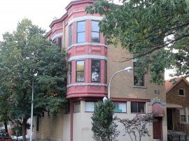
Remains of the “good old days” can still be found in Bucktown: cobblestone alleys; streetcar tracks peeking through potholes; a water pump in a yard near Leavitt and McLean; old street numbers in stained glass on Oakley; privy rooms under vaulted sidewalks; and, of course, our beautiful, sturdy century-old buildings.